The Tri-State Tornado
In 1925, the United States had no modern system for forecasting or warning the public about tornadoes. Meteorology was still a developing science, limited by sparse observational data, rudimentary models, and cultural caution about even using the word “tornado” in official communications. This context is essential to understanding why the Tri-State Tornado would prove so devastating.
Weather forecasting in the early twentieth century relied primarily on surface observations collected at widely spaced stations. Upper-air data, now critical for understanding severe storms, barely existed. Radiosonde balloons were not yet in operational use, radar was decades away, and weather maps were often several hours out of date by the time they were analysed. Forecasters could identify large-scale storm systems, but pinpointing violent local phenomena was beyond their capability.
Even more significant was an institutional constraint. The U.S. Weather Bureau actively discouraged the use of the term tornado in forecasts. Officials believed that mentioning tornadoes would cause panic and undermine public trust. As a result, warnings were vague, often referring only to “severe storms” or “high winds”, language that failed to convey immediate, life-threatening danger.
Public awareness and preparedness were similarly limited. Tornado safety guidance was inconsistent and often ineffective. Many people believed that opening windows would equalise pressure and prevent buildings from exploding, a myth that persisted for decades. Basements were uncommon in some rural areas, and storm shelters were rare. Schools, factories, and homes were not designed with high winds in mind, and building standards varied widely across states.
The Midwest and Ohio Valley regions, including Missouri, Illinois, and Indiana, were particularly vulnerable. These areas combined flat terrain, wooden construction, and dense working populations in mining and industrial towns. Communication between communities relied on telegraph, telephone, and word of mouth, all of which could be severed instantly by storms.
On the morning of 18 March 1925, millions of people went about their day with no reason to expect extraordinary danger. There were no sirens, no alerts, and no coordinated emergency response plans. When the storm system that would produce the Tri-State Tornado began to organise, it did so in a nation effectively blind to what was coming.
The disaster that followed was not only the result of extreme weather, but of a society without the tools, language, or systems to warn itself in time.

18 March 1925: Formation of an Unusual Storm over the Midwest
The weather pattern that produced the Tri-State Tornado began to take shape during the early hours of Wednesday, 18 March 1925. A strong low-pressure system was moving eastward across the central United States, drawing warm, moist air north from the Gulf of Mexico while colder air pushed south from the Plains. This unstable combination created ideal conditions for severe thunderstorms, even if forecasters at the time lacked the tools to recognise just how extreme the setup had become.
By mid-morning, thunderstorms were developing across parts of Missouri, particularly in the south-eastern portion of the state. Surface observations recorded rapidly falling air pressure, strengthening winds, and unusually warm temperatures for March. In some areas, the air felt heavy and oppressive, a detail frequently mentioned in later survivor accounts. To modern meteorologists, these conditions would signal a high risk of tornado activity. In 1925, they were simply noted and logged.
At approximately 1:00 p.m. local time, a powerful storm cell intensified near the town of Ellington, Missouri. Witnesses reported dark, low-hanging clouds and a roaring sound often compared to an approaching train. Somewhere in this region, the tornado first touched down, though the exact moment remains uncertain due to the lack of real-time observation. What is clear is that the storm quickly organised into a long-lived, violent tornado, maintaining contact with the ground for an extraordinary length of time.
Unlike most tornadoes, which lift and re-form repeatedly, this one followed a remarkably continuous path. It moved northeast at speeds estimated between 55 and 70 miles per hour, faster than many people could run or even react. This speed would later become one of its deadliest characteristics, giving communities almost no time to seek shelter even when visual warning signs were present.
As the tornado strengthened, it carved a growing path of destruction across rural Missouri. Farmhouses, barns, and small settlements were struck with little or no warning. Telegraph lines were torn down, cutting off communication ahead of the storm and ensuring that downstream towns remained unaware of what was approaching.
By early afternoon, the storm was no longer a local event. It was becoming a regional catastrophe, already displaying the speed, persistence, and violence that would soon devastate large parts of Illinois and Indiana before the day was over.
The Long Track of Destruction: Missouri, Illinois, and Indiana in a Single Afternoon
Once established, the Tri-State Tornado became a phenomenon unlike anything previously recorded. From its initial touchdown in Missouri, the tornado maintained a continuous ground track of approximately 219 miles, cutting across three states in just over three hours. Its persistence, speed, and intensity combined to produce devastation on a scale that communities along its path could neither comprehend nor escape.
After striking rural areas of south-eastern Missouri and destroying most of the city of Annapolis, the tornado crossed the Mississippi River and entered Illinois at around 2:30 p.m. It was here that the storm reached its deadliest phase. Moving at speeds estimated between 55 and 70 miles per hour, the tornado gave towns only minutes, sometimes seconds, of visual warning. Entire neighbourhoods were obliterated before residents could react.
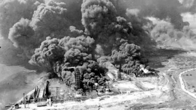
The hardest-hit community was Murphysboro, where the tornado struck directly through the centre of town. Schools, homes, factories, and churches were destroyed almost simultaneously. Fires broke out among the wreckage, fueled by overturned stoves and broken gas lines. Of Murphysboro’s population of roughly 12,000, 234 people were killed, making it the single deadliest tornado impact on a U.S. city in recorded history.
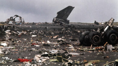
From there, the tornado continued northeast, tearing through towns such as De Soto, West Frankfort, and Parrish, 90% of which was destroyed. Entire communities were reduced to splintered lumber and exposed foundations. In many locations, debris was carried for miles, while heavy objects such as railcars and machinery were overturned or thrown from their original positions.
By early evening, the tornado crossed into Indiana, striking towns including Griffin and Owensville before finally dissipating around 4:30 p.m. near Princeton. Even in its final stages, the storm remained violent, continuing to level buildings and kill residents who had no warning of its arrival.
By the time the tornado lifted, it had injured more than 2,000 people and killed at least 695, leaving a scar across the Midwest that stretched beyond geography. It had demonstrated that a single storm, under the right conditions, could devastate multiple states in a single afternoon, rewriting the limits of known natural disasters.
Murphysboro and Beyond: Death Toll, Injuries, and the Communities Hit Hardest
As the Tri-State Tornado tore through the Midwest on 18 March 1925, the human cost escalated with terrifying speed. Nowhere was this more evident than in Murphysboro, the town that would come to symbolise the disaster’s scale. When the tornado struck shortly after 2:30 p.m., it cut directly through the heart of the community. Entire residential streets vanished. Schools collapsed with students still inside. Fires ignited across the ruins, compounding the destruction and trapping survivors beneath burning debris.
In addition to the 234 deaths, thousands more were injured, many suffering broken limbs, head trauma, and severe lacerations from flying debris. Hospitals were overwhelmed almost immediately. With roads blocked and communication lines destroyed, medical aid had to be improvised, often by neighbours treating neighbours amid the wreckage.
The devastation was not confined to one town. Across southern Illinois, communities such as De Soto and West Frankfort experienced catastrophic losses. In De Soto, a school was destroyed, killing 33 children and teachers. In West Frankfort, hundreds of homes were flattened, and dozens of residents died within minutes. Smaller settlements were erased almost entirely, their names surviving only in casualty lists and local memory.
By the time the tornado crossed into Indiana, it had already killed hundreds. Towns such as Griffin and Owensville suffered further fatalities, adding to the final death toll.
The pattern of casualties revealed why the tornado was so deadly. It struck during daylight hours, when people were at work or school, inside buildings that offered little protection. Its extreme speed left no time for escape. Entire families were killed together, leaving towns with sudden gaps in their population that could never be filled.
The Tri-State Tornado was not merely destructive. It was annihilating. Its death toll reflected a combination of violent meteorology and communities caught completely unprepared, a lesson written not in statistics alone, but in the sudden absence of hundreds of lives.
Why the Tri-State Tornado Was So Deadly: Speed, Path, and the Absence of Warnings
The extraordinary death toll of the Tri-State Tornado was not the result of a single factor, but of several lethal elements converging at once. In addition to the tornado’s unprecedented speed across the ground, there was the fact that it struck an exceptionally long and continuous path. The continuity of contact with the ground for 219 miles meant there were no natural breaks in destruction and no opportunity for downstream communities to learn from what had already occurred upstream. Telegraph and telephone lines were destroyed early in the storm’s path, cutting off communication ahead of the tornado.
As previously mentioned, the disaster took place during the day when children were at school, and people were at work, meaning that they were congregated together in buildings that were not designed for and could not cope with such a storm. Homes and public buildings were typically made of wood or unreinforced masonry, materials that offered little resistance to extreme winds. Basements and storm cellars were not universally available, particularly in poorer or rural areas. When buildings failed, they did so completely, turning walls, roofs, and furniture into lethal falling objects and projectiles.
Finally, the absence of effective warnings was decisive. The U.S. Weather Bureau did not issue tornado warnings, in part because the practice was discouraged nationwide. Officials feared that explicit mention of tornadoes would cause panic. As a result, communities received no advance notice beyond what they could see for themselves, which, given the storm’s speed, was often too late.
The Tri-State Tornado exposed the deadly consequences of silence, speed, and structural vulnerability. It was not merely the strength of the storm that killed so many, but the systems that failed to recognise and communicate the danger before it arrived.
Legacy of the Disaster: Changes to Tornado Science, Reporting, and Public Safety
The Tri-State Tornado left a legacy that extended far beyond the 695 confirmed deaths and thousands of injuries it caused. In the years that followed, it became a reference point for what happens when extreme weather meets scientific limitation and institutional caution. While change was slow, the disaster ultimately helped reshape how tornadoes were studied, discussed, and communicated to the public.
In the immediate aftermath, attention focused on documentation rather than prevention. Meteorologists began to reconstruct the storm’s path in detail, measuring its estimated 219-mile track, analysing survivor accounts, and comparing damage patterns across the three states. These efforts laid early groundwork for understanding long-track tornadoes and challenged assumptions about how long and how far a single tornado could travel without lifting.
One of the most significant long-term impacts involved communication policy. There was an internal debate about whether discouraging the use of the word tornado in forecasts was the right thing to do. While the policy did not change immediately, the catastrophe added weight to arguments that withholding explicit warnings posed a greater danger than public panic. By the 1950s, tornado warnings were formally introduced, marking a decisive shift in public safety strategy.
Advances in technology further transformed tornado preparedness. The introduction of weather radar in the mid-twentieth century, followed by Doppler radar in the late twentieth century, allowed meteorologists to detect rotation within storms before tornadoes touched down. Coupled with satellite imagery, these tools dramatically improved lead times for warnings, turning minutes into lifesaving opportunities.
Public education also evolved. The myths that dominated 1925, such as opening windows to prevent explosions, were gradually replaced with evidence-based safety guidance. Storm shelters, basements, and later, safe rooms, became standard recommendations. Sirens, emergency broadcasts, and coordinated response plans emerged at local and national levels.
Despite these advances, the Tri-State Tornado remains unmatched in its death toll. Modern warning systems have prevented similar catastrophes, but the storm is still used as a reference point for educating people about the dangers of complacency when it comes to storm warnings. The legacy of the Tri-State Tornado is not simply historical. It is embedded in every warning issued today, shaped by a disaster that proved silence could be as deadly as the storm itself.
The Tri-State Tornado FAQ
A single long-track tornado that struck Missouri, Illinois, and Indiana on 18 March 1925.
At least 695 people were killed, with more than 2,000 injured.
Its extreme speed, long continuous path, daytime timing, and the absence of warnings made escape nearly impossible.
Murphysboro, Illinois, where 234 people were killed, the highest death toll for a single town in a U.S. tornado.
Yes. It influenced later acceptance of tornado warnings and contributed to advances in forecasting and public alert systems.