The Mount Pelée Eruption
Mount Pelée dominates the northern end of the Caribbean island of Martinique, rising to 1,397 metres above sea level. It is a stratovolcano, steep-sided, forested, and visually dramatic, but for most of the nineteenth century, it was not regarded as especially dangerous. By 1902, Pelée had become part of the island’s scenery rather than a perceived threat, a backdrop to daily life rather than a force demanding caution.
Martinique itself was a French colony, formally integrated into France in 1848, with a population of around 200,000 at the turn of the twentieth century. Its economic and cultural heart was the town of Saint-Pierre, located roughly six kilometres south-west of Mount Pelée. Saint-Pierre had a population of about 28,000 in 1902 and was often referred to as “the Paris of the Caribbean”. It had theatres, newspapers, electric lighting, tramways, and a busy harbour exporting sugar, rum, and cocoa. The town’s prosperity rested on the assumption that the volcano looming above it was largely benign.
Mount Pelée was not dormant. Historical records show minor eruptions in 1792 and again in 1851. Both events involved ash emissions and steam explosions but caused no widespread destruction or loss of life. These earlier episodes shaped public and official attitudes. Pelée was classified informally as an irritant rather than a killer, capable of mess but not massacre. No systematic volcanological monitoring existed on Martinique at the time. There were no seismographs, gas measurements, or evacuation plans tied to volcanic activity.
Geologically, Mount Pelée sits on the Lesser Antilles volcanic arc, formed by the subduction of the Atlantic Plate beneath the Caribbean Plate. This tectonic setting is capable of producing highly explosive eruptions, particularly from viscous, gas-rich magma. However, this scientific understanding was limited in 1902, and the concept of pyroclastic density currents had not yet been fully developed or widely recognised.
Culturally and politically, Saint-Pierre’s position mattered. It was the administrative capital of Martinique, home to the island’s elite and central to its economy. Relocating or evacuating such a town was unthinkable without overwhelming evidence of danger. As a result, Mount Pelée entered the spring of 1902 as a volcano with a known history, an imposing presence, and a deeply misleading reputation: active, yes, but not deadly. That assumption would prove catastrophic.
April–Early May 1902: Warning Signs, Official Decisions, and the Failure to Evacuate Saint-Pierre
The first clear warning signs from Mount Pelée appeared in late April 1902. On 23 April, residents near the summit reported sulphurous smells and faint ash emissions, events that were unusual but not unprecedented. Two days later, on 25 April, small explosions were observed from the crater, ejecting ash and steam. Ash fell on nearby villages, lightly dusting roofs and crops, but caused no immediate damage. Life in the nearby town of Saint-Pierre continued essentially unchanged.
By 27 April, seismic activity had increased. Earth tremors were felt across northern Martinique, and ashfall became heavier, darkening skies during daylight hours. On 2 May, a more serious event occurred when a lahar, a fast-moving volcanic mudflow triggered by heavy rain and loose ash, swept down the Rivière Blanche valley. It destroyed the Guérin sugar works and killed at least 23 workers. This was a critical escalation. It demonstrated that Mount Pelée was no longer merely venting ash but actively generating lethal hazards.
Despite this, evacuation orders were not issued. Colonial authorities in Saint-Pierre sought reassurance rather than alarm. A local scientific commission was formed on 6 May, led by Georges Landes, a teacher of physics rather than a volcanologist. The commission concluded that the greatest danger lay to the north of the volcano and that Saint-Pierre, positioned to the south-west, was relatively safe. This assessment was disastrously wrong.
Several factors contributed to the failure to evacuate. Legislative elections were scheduled for 11 May 1902, and officials feared that mass movement of people would disrupt voting and cause panic. The port of Saint-Pierre remained active, even as ash continued to fall, sometimes thick enough to require street lamps to be lit during the day. By 7 May, volcanic bombs, some as large as fists, landed on the outskirts of the town. Snakes and insects fled the volcano’s slopes, entering populated areas, another sign widely noted but poorly interpreted.
By the evening of 7 May, roughly 28,000 people were still in Saint-Pierre, including refugees from smaller northern villages who had fled towards what they believed was safety. Ships in the harbour kept steam up, aware of danger but not ordered to leave. At no point was a general evacuation mandated.
The warnings were there, accumulating over nearly two weeks. What failed was not observation but interpretation, authority, and the willingness to act decisively in the face of uncertainty.
8 May 1902, 07:52 a.m.: The Pyroclastic Surge That Destroyed Saint-Pierre in Minutes
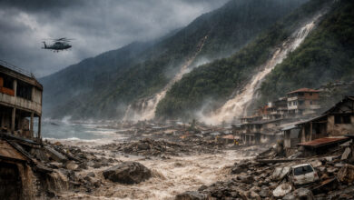
At 07:52 a.m. on Thursday, 8 May 1902, Mount Pelée erupted with catastrophic force. Without a large, prolonged explosion, the volcano expelled a dense, superheated cloud of gas, ash, and volcanic debris from a newly opened vent on its south-west flank. This phenomenon, later identified as a pyroclastic density current, travelled directly towards the town of Saint-Pierre, six kilometres away.
The cloud descended the mountainside at an estimated speed exceeding 100 kilometres per hour, though some later analyses suggest it may have been significantly faster. Temperatures within the surge are believed to have exceeded 400 degrees Celsius, hot enough to ignite wood, melt metal fittings, and cause instant fatal burns to human skin and lungs. Witness accounts from ships anchored offshore described a rolling black wall racing down the mountain, followed by total darkness.
The pyroclastic surge reached Saint-Pierre in under one minute. The town was effectively annihilated almost instantaneously. Buildings collapsed, roofs were blown inward, and fires ignited across the urban area. Wooden structures burned within seconds, while stone buildings were stripped of doors, windows, and internal fittings. People caught outdoors died immediately from thermal shock and asphyxiation. Those indoors fared little better. Superheated gases penetrated enclosed spaces, killing occupants where they stood or lay.
The harbour offered no refuge. The surge swept across the waterfront, capsizing small boats and setting ships ablaze. At least 17 vessels in the bay were damaged or destroyed. Many sailors were killed by burns or suffocation, while others jumped into the sea to escape the heat, only to be scalded by boiling water near the shore. A handful of crew members survived by cutting anchor lines and fleeing into open water within minutes of the eruption.
Within less than ten minutes, Saint-Pierre had ceased to exist as a town. Communication lines were destroyed, the port was incapacitated, and fires raged uncontrollably. Of the approximately 28,000 people in the town that morning, all but a handful were dead by the time the cloud dissipated.
The eruption did not produce extensive lava flows. Its lethality came from speed, heat, and direction. Mount Pelée had demonstrated a form of volcanic violence that science had not yet fully named, but which had already rewritten the limits of natural disaster.
Survival, Death, and Misconception: Who Lived, Who Didn’t, and Why the Numbers Matter
In the immediate aftermath of the eruption of Mount Pelée, estimates of the death toll varied wildly. Within weeks, a grim consensus formed: approximately 28,000 people in Saint-Pierre had been killed in a matter of minutes. Later historical and demographic studies have adjusted the figure slightly, generally placing it between 28,000 and 30,000 deaths when nearby villages and ships in the harbour are included. The exact number will never be known, but the scale of loss is beyond dispute.
For decades, popular accounts claimed that only two people survived the destruction of Saint-Pierre. This is incorrect. At least three confirmed survivors are known from within the city, with a small number of others surviving on the outskirts or aboard ships that managed to escape. The most famous was Ludger Sylbaris, a prisoner held in an underground stone cell at the city jail. His cell had thick walls, minimal ventilation, and a single small opening. When the pyroclastic surge passed through the city, the structure shielded him from the direct blast and intense heat. Sylbaris suffered severe burns and dehydration but was found alive four days later.
Another survivor was Léon Compère-Léandre, a shoemaker who lived on the edge of the city and was partially shielded by terrain and buildings. A third, Havivra Da Ifrile, a young girl, escaped by fleeing towards the sea moments before the surge arrived. Their survival was not miraculous in the supernatural sense but the result of highly specific physical circumstances that reduced exposure to heat and toxic gases.
The vast majority of victims died almost instantly. Autopsies and medical examinations conducted on recovered bodies showed little evidence of prolonged suffering. Many victims were found in natural postures, suggesting death within seconds, caused by thermal shock to the lungs, asphyxiation, and severe burns to internal organs. This detail matters. It counters later sensationalist claims of slow, agonising deaths and reinforces the true nature of pyroclastic density currents as overwhelmingly lethal, fast-moving phenomena.
The persistence of myths surrounding survival and death at Saint-Pierre has often distracted from the central reality. This was not a story of lucky escapes but of near-total destruction. The numbers matter because they underscore a simple truth: once the eruption began, survival inside the city was almost impossible.
Aftermath on Martinique: Fires, Secondary Eruptions, and the End of Saint-Pierre as a Capital
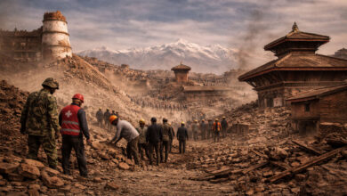
When the pyroclastic surge receded on the morning of 8 May 1902, Martinique was left in a state of near-total shock. Saint-Pierre was not merely damaged; it was effectively erased. Fires burned uncontrollably for days, fed by ruptured rum stores, warehouses, and wooden housing. Smoke rose continuously from the ruins, visible for miles at sea. Rescue efforts began almost immediately, but they were hampered by heat, unstable structures, and the sheer scale of devastation.
Initial relief ships arrived from Fort-de-France, approximately 25 kilometres to the south, later that same day. What they found defied comprehension. Streets were blocked by collapsed buildings, bodies lay where people had fallen, and the harbour was choked with burned and sunken vessels. Survivors were so few that the organised rescue quickly shifted into recovery and containment. Sanitation became a pressing concern, as decomposing bodies and stagnant water posed a serious risk of disease.
The danger had not passed. Mount Pelée remained active throughout the summer of 1902. On 20 May, another powerful eruption killed an estimated 2,000 people in nearby villages, including Morne Rouge. Further eruptions followed on 6 June, 9 July, and 30 August, each reinforcing the understanding that Pelée was capable of repeated, deadly events rather than a single catastrophic outburst. The volcano would not fully subside until late 1905.
Saint-Pierre never recovered its former status. Before the eruption, it had been the economic and administrative centre of Martinique. Afterwards, those functions shifted permanently to Fort-de-France, which had escaped significant damage. The decision was not ideological but practical. Saint-Pierre’s infrastructure was gone, its population destroyed, and its geographic position beneath the volcano now understood as fatally vulnerable. Rebuilding occurred slowly and on a much smaller scale. By 1910, the town had only a few thousand residents.
International aid flowed to Martinique in the months following the disaster. France sent financial assistance, medical teams, and engineers, while donations arrived from the United States, Europe, and other Caribbean territories. Yet no amount of aid could reverse the fundamental change brought by the eruption. Entire families, businesses, and social networks had vanished in minutes.
The aftermath of the Mount Pelée eruption was not defined by recovery in the usual sense. It marked a permanent shift in the island’s political, economic, and demographic landscape. Saint-Pierre survived in name, but the capital of Martinique, both in practice and in memory, had moved on.
Scientific Legacy: How Mount Pelée Changed Volcanology and the Understanding of Pyroclastic Flows
The eruption of Mount Pelée in 1902 marked a turning point in the scientific understanding of volcanic hazards. Before Saint-Pierre was destroyed, volcanology existed mainly as a descriptive science. Eruptions were catalogued, lava flows mapped, and ash clouds observed, but the mechanisms behind the most lethal volcanic phenomena were poorly understood. Pelée forced a reckoning.
In the months following the disaster, scientists studying the ruins recognised that traditional explanations did not fit the evidence. There were no extensive lava flows, yet the city had been obliterated. Buildings were burned from the inside, bodies showed signs of extreme heat exposure without burial by ash, and damage patterns indicated a lateral blast rather than a vertical eruption. These observations led to the identification of a new category of volcanic event: the nuée ardente, or “glowing cloud”, a term later refined into what is now known as a pyroclastic density current.
This concept fundamentally altered volcanic risk assessment. Pyroclastic flows were recognised as fast-moving, ground-hugging mixtures of hot gas, ash, and rock fragments, capable of travelling at speeds exceeding 100 kilometres per hour and killing everything in their path almost instantly. Crucially, Pelée demonstrated that such flows could move sideways, not just downhill from a summit crater, and could be channelled by terrain toward populated areas thought to be safe.
The scientific lessons of 1902 directly influenced monitoring and evacuation strategies worldwide. Volcanoes previously considered manageable due to infrequent lava flows were reclassified as potentially catastrophic if capable of dome collapse or lateral venting. Later eruptions, including Mount St. Helens in 1980, were interpreted through the analytical framework first shaped by Pelée.
Mount Pelée also reshaped the relationship between science and public authority. The failure of the 1902 scientific commission, composed mainly of non-specialists and operating under political pressure, became a cautionary example. In response, governments increasingly recognised the need for trained volcanologists, permanent observatories, and clear evacuation protocols independent of political calendars or economic concerns.
Today, Pelée is one of the most studied volcanoes in the world. Continuous monitoring systems now track seismic activity, gas emissions, and ground deformation. While these tools cannot prevent eruptions, they dramatically improve the chances of timely evacuation. The eruption’s legacy is enduring. Saint-Pierre was destroyed in minutes, but the knowledge gained from its loss has saved countless lives since. Mount Pelée taught the world that volcanic danger is not always slow, visible, or negotiable. Sometimes, it arrives sideways, at speed, and without mercy.
The Mount Pelée Eruption FAQ
A fast-moving pyroclastic density current from Mount Pelée swept through the city, killing most residents within seconds.
Approximately 28,000 people were killed in Saint-Pierre, with additional deaths in nearby villages and at sea.
Officials underestimated the danger, relied on flawed scientific advice, and feared political disruption ahead of elections.
Yes. A small number survived due to unusual circumstances, including Ludger Sylbaris, who was shielded in a stone prison cell.
The eruption led to the recognition of pyroclastic flows as one of the deadliest volcanic hazards.