The Vajont Dam Disaster
The Vajont Valley lies in northeastern Italy, near the border between the regions of Veneto and Friuli-Venezia Giulia, carved deep into the southern edge of the Dolomites. It is a narrow, steep-sided gorge, shaped by glaciers and water erosion, with near-vertical limestone walls rising hundreds of metres above the valley floor. Long before the disaster of 1963, the landscape itself carried visible signs of instability.
Above the valley loomed Monte Toc, a mountain whose name in the local dialect roughly translates as “the rotten mountain”. This was not poetic exaggeration. The slopes consisted of layered limestone interspersed with clay-rich strata, a geological structure prone to sliding when saturated with water. Evidence of ancient landslides was clearly visible in the terrain, with scarred slopes and displaced rock formations indicating that large-scale movement had occurred in the past.
Despite these risks, the Vajont Valley attracted the attention of engineers and planners in the post-war years. Italy emerged from the Second World War with an urgent need for energy to fuel reconstruction and industrial expansion. Hydroelectric power was seen as clean, modern, and nationally strategic. The Vajont Gorge, narrow and deep, appeared ideal for a high arch dam capable of holding back an enormous volume of water.
The nearby communities, including Longarone, Pirago, Rivalta, and Villanova, were small working-class towns and villages. Their economies were based on agriculture, forestry, and local trade. Many residents were aware of the valley’s history of minor landslides and rockfalls, but these were treated as natural inconveniences rather than existential threats. There was little public consultation about large-scale engineering projects, and opposition carried limited weight in a period dominated by national development priorities.
What made the Vajont Valley especially dangerous was not simply its geology, but its confinement. Any sudden displacement of material into the narrow gorge would have nowhere to dissipate energy. Water, rock, and debris would be forced upward and outward with immense violence. This was a basic physical reality, well understood in theory, but underestimated in practice.
By the early 1950s, the Vajont Valley was seen less as a living landscape and more as a technical opportunity. Its risks were documented, but its potential was prioritised. The stage was set for a project that would test the limits of engineering confidence against geological truth, in a place where failure would have nowhere to go but straight through the communities below.
Building the Vajont Dam: Engineering Confidence and Ignored Geological Warnings
Construction of the Vajont Dam began in 1956, driven by Italy’s post-war push for hydroelectric power and industrial growth. Built by the state-owned energy company Società Adriatica di Elettricità (SADE), the dam was designed as a double-curvature concrete arch, anchored into the steep limestone walls of the Vajont Gorge. When completed in 1960, it stood 261.6 metres high, making it one of the tallest dams in the world. From an engineering perspective, it was a masterpiece. From a geological one, it was built in the wrong place.
From the outset, geologists working in the valley identified signs of instability on Monte Toc, the mountain rising above the planned reservoir. The slopes showed evidence of ancient landslides, fractured rock layers, and clay seams capable of acting as slip planes when saturated. These findings were documented in reports submitted during the planning and construction phases. The risks were known, but they were treated as manageable rather than decisive.
SADE’s approach rested on confidence in control. The company believed that by carefully regulating the reservoir’s water level, any movement of the mountainside could be stabilised. Test fillings of the reservoir were carried out between 1960 and 1963, during which small landslides and tremors were repeatedly observed. Instruments recorded ground movement, and residents reported cracking buildings and rumbling sounds. Each incident confirmed instability, yet operations continued.
Crucially, the dam itself was never considered the weak point. Engineers were correct in one sense. The structure was designed to withstand immense pressure and would later survive the disaster intact. This focus on structural strength, however, diverted attention from the surrounding terrain. Geological risk was reframed as an operational problem, something that could be controlled through monitoring rather than avoided through redesign or abandonment.
As water levels rose, so did the speed of the landslide on Monte Toc. By September 1963, the movement had accelerated dramatically, reaching several centimetres per day. Emergency drawdowns were attempted, but the response came too late. The mass of unstable rock, estimated at over 260 million cubic metres, was already primed to fail.
The Vajont project was not built in ignorance. It was built in defiance of accumulating evidence, guided by a belief that technical expertise could compensate for geological reality. The dam was an engineering triumph placed within a landscape that had been warning, repeatedly and clearly, that it could not be trusted.
9 October 1963, Evening: The Landslide That Fell into the Reservoir
By the evening of 9 October 1963, the instability of Monte Toc had reached a critical point. For weeks, instruments had recorded accelerating movement on the mountainside above the Vajont reservoir. What had once been measured in millimetres was now measured in tens of centimetres per day. Engineers were aware that a major collapse was increasingly likely, but the scale and speed of what followed exceeded even the most pessimistic internal estimates.
That day, the reservoir level had been partially lowered in an attempt to reduce pressure on the slope. The water surface sat at approximately 700 metres above sea level, well below the maximum operating level. This reduction, however, came too late. The mountain had already been destabilised by repeated filling and drawdown cycles, which allowed water to penetrate clay layers deep within the rock mass, lubricating the slip plane beneath the slope.
At approximately 10:39 p.m., the entire northern flank of Monte Toc gave way. An estimated 260 to 270 million cubic metres of rock detached almost simultaneously and slid into the reservoir. The landslide travelled at speeds later estimated at up to 30 metres per second, generating a sound described by witnesses as a continuous thunderous roar rather than a single collapse.
The mass of rock did not fall vertically. It slid as a coherent block, maintaining much of its internal structure as it plunged into the narrow reservoir basin. The displacement was so sudden and so vast that the reservoir water had nowhere to go but up. Within seconds, the landslide displaced nearly all the water in the Vajont basin.
Crucially, the Vajont Dam itself did not fail. The concrete structure remained structurally intact, exactly as its designers had predicted. This fact would later become central to the tragedy’s interpretation. The disaster was not caused by a dam collapse, but by the interaction between an unstable mountain and a confined body of water.
There was no meaningful warning to downstream communities. The collapse occurred at night, without time for evacuation. The landslide was over in less than a minute, but it set in motion a sequence of events that would destroy entire towns.
In that instant, years of geological warnings, incremental movements, and deferred decisions were resolved into a single, irreversible act. The mountain moved. The reservoir responded. And the energy released would travel far beyond the dam itself.
The Wave That Overtopped the Dam: Destruction of Longarone and Nearby Villages
When the massive landslide slammed into the Vajont reservoir, the water it displaced was forced violently upward. With nowhere to spread laterally in the narrow gorge, the reservoir responded by generating an enormous surge. Estimates later concluded that the wave rose between 200 and 250 metres above the waterline, an almost unimaginable height, before spilling over the dam’s crest.
Approximately 25 to 30 million cubic metres of water overtopped the Vajont Dam in a matter of seconds. The dam itself remained standing, but the water that passed over it became a weapon. Accelerating down the valley at extreme speed, the wave struck the settlements below with overwhelming force.
The town of Longarone, located directly downstream, was hit first. Within moments, the flood obliterated the town centre. Buildings were flattened, streets scoured to bare rock, and debris was carried kilometres downstream. The wave did not behave like a conventional flood. It arrived as a wall of water mixed with mud, trees, and rubble, powerful enough to lift reinforced concrete structures and sweep them away entirely.
Nearby villages suffered similar fates. Pirago, Rivalta, Villanova, and parts of Faè were devastated or erased. In some locations, the water rose more than 20 metres above ground level. Residents had no warning and no chance to escape. Many were asleep when the wave arrived. Others were caught attempting to flee, overwhelmed within seconds.
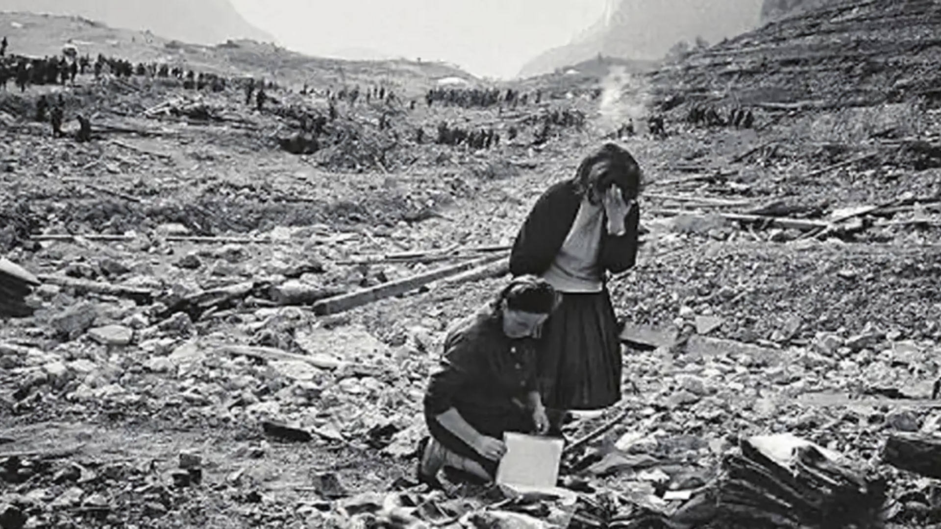
The violence of the surge was such that bodies and debris were carried far beyond the immediate impact zone. Some victims were found kilometres downstream in the Piave River valley. In Longarone, only a small number of buildings on higher ground remained standing.
Within minutes, the water had passed, leaving silence where communities had stood. Fires broke out amid the wreckage, and survivors wandered through darkness and devastation, searching for family members in a landscape that no longer resembled a town.
By the end of the night, it was clear that one of the deadliest engineering-related disasters in European history had occurred. The wave that overtopped the Vajont Dam demonstrated that structural survival was meaningless when the surrounding environment had been fatally misjudged. The dam stood, but the communities below it were gone.
Death Toll, Responsibility, and the Italian State on Trial
When daylight broke on 10 October, the scale of the Vajont disaster became clear. Entire towns had been erased in minutes. The official death toll was recorded as 1,917 people, though some estimates place the number higher due to missing bodies and entire families being wiped out. In Longarone, more than 1,400 residents were killed, representing the vast majority of the town’s population. In several nearby villages, survival rates were similarly low.
The shock quickly turned to anger. The fact that the Vajont Dam remained standing became a grim symbol of misdirected priorities. The structure had performed exactly as designed, yet the disaster had still occurred. Attention focused on how a project so clearly surrounded by geological instability had been allowed to proceed, and why repeated warning signs had failed to stop it.
Responsibility centred on SADE, the electricity company that planned and built the dam, and later on ENEL, the state-owned company that absorbed SADE shortly before the disaster as part of Italy’s energy nationalisation. Internal documents revealed that engineers and geologists working for SADE had long been aware of the landslide risk on Monte Toc. Reports warning of large-scale slope failure were downplayed, reframed, or ignored. Instead of abandoning the project, the company chose to manage the risk through water-level control.
The Italian state was also implicated. Government agencies approved the project, accepted reassurances from SADE, and failed to act decisively when danger escalated. Local authorities were given limited information and had no power to order evacuations. Residents downstream were never informed of the true scale of the risk they faced.
Legal proceedings began in the late 1960s and culminated in 1969 with a criminal trial in L’Aquila. Several SADE and ENEL officials were charged with manslaughter and negligence. In 1971, a small number of senior engineers and executives were convicted and sentenced to prison terms, though most sentences were reduced on appeal. No senior political figures were held criminally responsible.
Civil compensation followed, but it was slow and uneven. Survivors and families of victims received financial settlements, yet many felt these payments could never reflect the loss of entire communities. The trial exposed a disturbing truth. Vajont was not a natural disaster. It was the result of decisions made with knowledge of the risks, in which economic ambition and institutional authority overrode geological reality and human safety.
The Italian state itself had been placed on trial, not just in court, but in public memory.
After Vajont: Lessons in Engineering Hubris and Disaster Prevention
In the years following the Vajont disaster, Italy was left to grapple with a catastrophe that could not be explained away as bad luck or natural misfortune. The dam still stood, an uncomfortable monument to what had gone wrong. Vajont forced a reckoning with the limits of engineering confidence and the consequences of treating complex natural systems as variables to be managed rather than forces to be respected.
Reconstruction began quickly, but it could never truly replace what had been lost. Longarone was rebuilt on higher ground, deliberately away from the original flood path. Memorials were erected, and the valley became a site of remembrance rather than development. The reservoir was permanently abandoned. Water levels were never restored, and the scar of the landslide on Monte Toc remains visible, frozen in place as geological evidence of failure.
From an engineering and regulatory perspective, Vajont became a case study taught around the world. It reshaped how dam safety was understood, shifting focus beyond structural integrity to include geology, slope stability, and reservoir-induced landslides. The disaster demonstrated that a dam can be technically sound and still cause mass death if its environment is misjudged. This lesson influenced dam projects globally, leading to stricter geological surveys, independent reviews, and greater caution when building in unstable terrain.
Vajont also changed how responsibility is discussed in technological disasters. The engineers involved were not ignorant, nor were they reckless in the conventional sense. They gathered data, monitored movement, and believed they could control the outcome. The failure lay in overconfidence, in the belief that observation equalled control and that warning signs could be managed indefinitely without decisive action.
Public trust in large infrastructure projects was permanently altered. Vajont joined a short list of disasters that made scepticism rational. Communities downstream of dams began demanding transparency, emergency planning, and the right to be informed of risks. The idea that experts alone could decide acceptable danger without public consent became harder to defend. Today, the Vajont Dam is often described as the dam that did not break. That description misses the point. Vajont broke something more important than concrete. It broke the assumption that technical brilliance can compensate for ignoring nature’s limits. The valley remains quiet now, but its lesson endures: disasters are not always caused by collapse. Sometimes they are caused by success applied in the wrong place, for too long, and against better judgment.
The Vajont Dam Disaster FAQ
A massive landslide from Monte Toc fell into the reservoir, displacing water that overtopped the dam and destroyed towns downstream.
No. The dam remained structurally intact. The disaster was caused by the interaction between an unstable mountainside and the reservoir.
Approximately 1,900 people were killed, most of them in the town of Longarone.
Investigations found responsibility lay with the dam’s operators and state authorities who ignored geological warnings.
It is a key case study in engineering ethics, showing that technical success cannot compensate for ignoring environmental risk.